RoadPeace National Road Victim Month
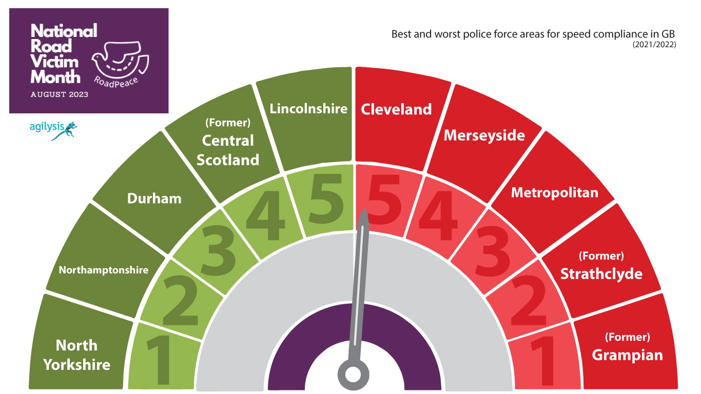
RoadPeace approached us and asked whether we could provide some analysis on speed compliance across the whole of Great Britain. Using our connected vehicle data which underpins tools such as the speed compliance tool, we were able to map speed compliance by police force area.
The data has been released to coincide with National Road Victim Month, which kicks off today in the UK, to highlight the risks posed by vehicles driving at excessive and inappropriate speeds every day on our roads.
Speeding is a major contributory factor in road collisions, and RoadPeace has supported countless crash victims and bereaved families in its 30-year history, whose lives have been torn apart by speeding drivers.
In the 30-year period since RoadPeace was formed, between the start of 1992 and the end of 2021, a staggering 81,315 people were killed and 7,245,833 were reported injured.*

The majority of modern private and commercial vehicles on our road network are now ‘connected’ – they are constantly connected to the internet, transmitting data in real time.
This data is used to calculate both the average and high-end (85th percentile) speeds across the whole road network, which is matched to known speed limit and traffic volume data, to provide an estimated number of speeding drivers across any part of the road network.
This has been aggregated by police force area to show the percentage of vehicles breaking the speed limit in each of these areas.
The data in this particular sample was taken between April 2021 and March 2022 and is based on 14 billion journeys on roads across Great Britain.
Commenting on our connected vehicle data Richard Owen said “This type of data can’t be used for tracking individual vehicles, but is perfectly placed to get a good sense of speeds on our roads. Much in the same way that something like Google Maps might show traffic delays, this allows us to see where speeds are significantly above the limit.”
The data signals a major step forward in road casualty reduction, with local authorities and police forces now able to understand where drivers are exceeding the speed limits before collisions occur.
This intelligence will help them to increase preventative measures on problematic routes, such as increased enforcement or improved engineering – helping to prevent a speed-related collision.
In the past, they had to rely on labour-intensive speed surveys at specific locations, speed camera offence statistics or casualty data to understand how prevalent speeding was in their area – which only provided a limited picture. And relied heavily on waiting for crashes to happen or for people to be injured in order to take action.
Nick Simmons, CEO of RoadPeace, the national charity for road crash victims, said: “Several decades ago, drink driving, although illegal, was considered socially acceptable and many drivers thought nothing of getting behind the wheel after they had been drinking. Thankfully, after years of education about the huge risks posed by drink driving, the majority of road users would never dream of driving after a drink and drink drivers are rightly seen by society as the selfish, reckless people that they are.”
“Speeding is a major contributory factor in the majority of collisions on our roads - it shatters lives, destroys families and communities live in fear of it – so why don’t we see speeding as the antisocial epidemic that it is?
As part of this release, RoadPeace is sharing stories of some of their members throughout the month of august via their YouTube page to urge drivers to think twice about driving at excessive or inappropriate speeds.


